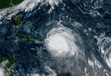
It’s been a week since Hurricane Irma ripped through Florida leaving behind a path of destruction and just as Floridians are getting back on their feet a new hurricane is churning. Hurricane Maria is a category two storm in the Atlantic that has many holding their breath.
On Monday Maria is expected to strike the Leeward Islands as a category two and strengthen early Tuesday morning into a three before taking a path to the Virgin Islands and Puerto Rico. The northeast part of the Caribbean expecting a strike from Maria is still recovering from Irma’s wrath two weeks ago.
That wrath is what has Floridians tensed as Maria continues to figure out the path it will take. Right now forecasters believe Hurricane Jose may pave the way for Maria to stay out in the Atlantic away from the U.S.
However, the curve many models are predicting the storm to take is still five to six days out, which Irma already proved to show is too far away to determine exactly where the storm will go.
As of now models predict Maria to curve away from the East Coast of the U.S. and will begin making that shift Friday night into Saturday morning.
Just as conditions were favorable for Imra, atmospheric conditions are again working in favor of Maria. As the storm moves through the Caribbean Islands, it will likely strengthen into a dangerous hurricane due to low wind shear, a moist atmosphere, and warm ocean water temperatures.
Hurricane #Maria Advisory 8A: Hurricane Hunter Aircraft Reports Maria Intensifying. https://t.co/VqHn0uj6EM
— NHC Atlantic Ops (@NHC_Atlantic) September 18, 2017
As Maria interacts with Puerto Rico and/or Hispañola the track will change and/or intensify. For now hold tight and don’t panic, it’s too early to tell how the hurricane will impact Florida and the East Coast.
Only 3 times before have 2 #hurricanes tracked w/in 75 mi. of the Virgin Isl. in the same season: 1999, 1916, 1852. Never 2 Cat 3+. #Maria pic.twitter.com/7hT75N6SA8
— Jonathan Erdman (@wxjerdman) September 17, 2017


